


Big Island of Hawaii: Mauna Loa’s volcano alert level to Advisory status
USGS raises Mauna Loa’s volcano alert level to Advisory status
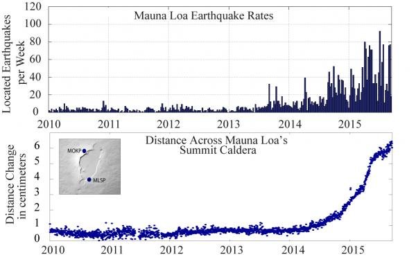
TOP: Mauna Loa weekly earthquake rates between 2010 and September 17, 2015. Blue bars indicate the number of earthquakes that were located by the USGS Hawaiian Volcano Observatory seismic network. Earthquakes of all magnitudes are plotted. Subtle increases in earthquake rates started in mid-2013, while more obvious changes in rates started in 2014.
BOTTOM: Change in distance across Mauna Loa’s summit caldera between 2010 and September 17, 2015. Blue dots indicate the relative distance between two stations that span the summit caldera of Mauna Loa, shown in the map on the upper left. Sustained extension across the caldera started in mid-2014. This extension is one of the indicators of magma infilling a complex reservoir system beneath the summit and upper Southwest Rift Zone.
In response to the status change, HVO is now posting weekly Mauna Loa updates on the HVO website (hvo.wr.usgs.gov/activity/mauna…). It is possible to receive these updates via email by signing up for HVO notices through the free USGS Volcano Notification Service (volcanoes.usgs.gov/vns/).
“The alert level change at Mauna Loa reminds us that it is an active volcano that will erupt again someday, so we should be prepared,” said Frank Trusdell, an HVO geologist who has extensively studied and mapped Mauna Loa. To facilitate public awareness and preparedness, HVO has posted on its website “Frequently Asked Questions about Mauna Loa” (hvo.wr.usgs.gov/maunaloa/FAQ_M…). Current monitoring data for Mauna Loa is also posted on the HVO website athvo.wr.usgs.gov/maunaloa/curre….
- 14 comments


Comments
- - Nov 29, 1999 2:00:00 PM
I found this blog. Much appreciation to you for offering to us everything considered, find some new data from your post. to a do my paper for me cerebrum boggling degree satisfying and I to an amazing degree like your article a commitment of Thankfulness is everythingjessica alex
- - Nov 29, 1999 2:00:00 PM
The conflict was about self determination: a people's right to decide their own fate. Best Assignment Writing UKSofia Watson
- - Nov 29, 1999 2:00:00 PM
They are for events that may cause significant inconvenience, and if caution is not exercised, it could lead to situations that may threaten life and/or property. best dissertation help serviceMichael James
- - Nov 29, 1999 2:00:00 PM
The Mauna Loa fountain of liquid magma in Hawaii has been hit by in any event 50 little quakes since October of a year ago, researchers said on Tuesday, inciting U.S. geologists to raise its alarm level to yellow. An emission of Mauna Loa, the world's biggest https://www.assignmentdone.co.uk/ dynamic fountain of liquid magma, did not seem, by all accounts, to be up and coming.jenny gunn